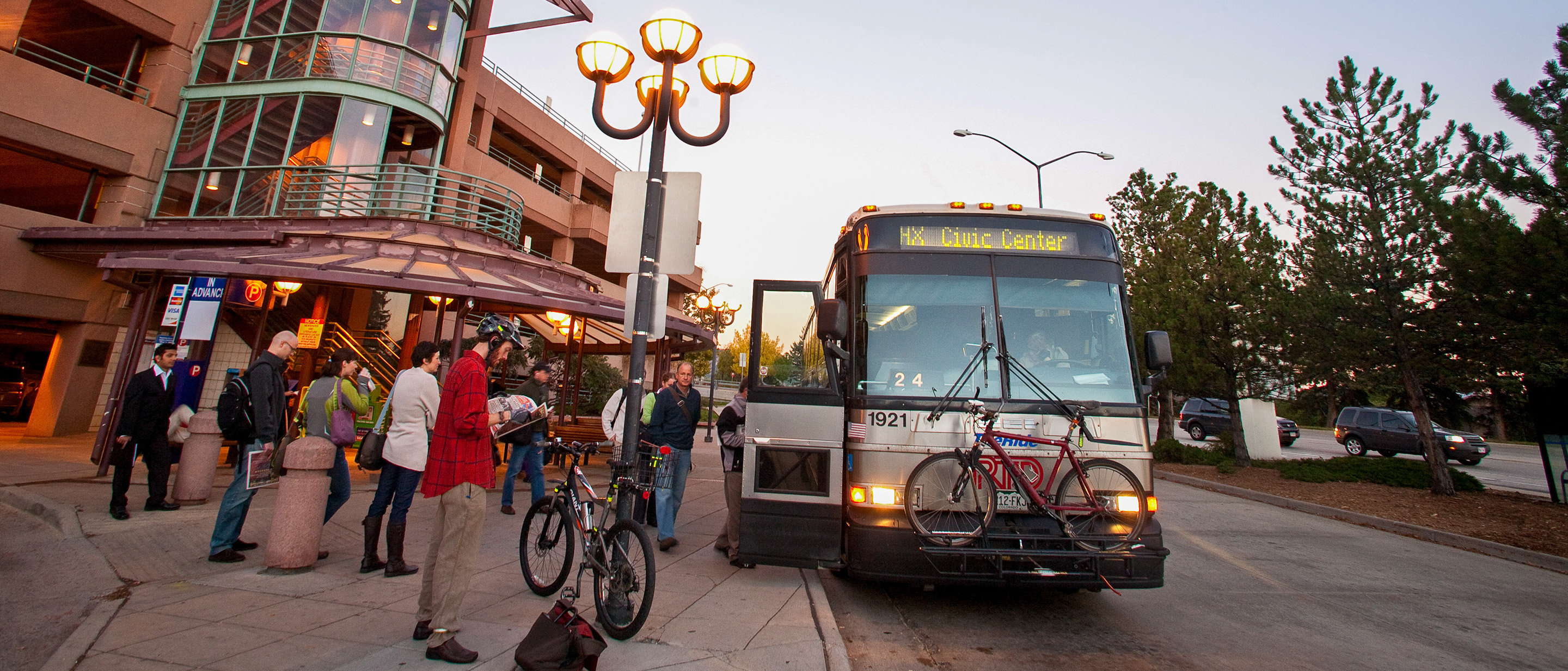
Bus Stop Consolidation
As traffic continues to worsen across the Denver metro area, RTD makes changes to our bus and rail system that are necessary in order to provide the most productive and efficient transit system for our passengers and the communities we serve. To improve bus travel across the district, we have started consolidating bus stops that are underutilized or bus stops that are within close proximity to other bus stops.
Why Consolidate Bus Stops?
To improve the quality and reliability of bus service, RTD is systemically analyzing bus stops by route based on usage and spacing. Through this process, we’ve developed a plan to remove bus stops while still providing adequate access to our riders. Our goal is to prioritize bus stop locations with enhanced safety features, and remove underutilized bus stops or stops close to other stops in an effort to improve our riders’ experience, with faster trip times and less dwell times
Improvements to speed and reliability are important features for frequent service and overall transit performance which helps attract new transit riders. Providing convenient transportation that gets passengers to their destinations in less time and on time becomes an attractive replacement for private vehicle use.
What does this Mean for You?
According to a Portland study, bus stop consolidation improved bus speeds by six percent. The transit industry has standards for stops per mile, depending on population density. Our goal is to consolidate bus stops to meet industry guidelines, which would space bus stops every ¼-mile. Bus stops will still be located near key intersections, major activity generators and areas to accommodate people with disabilities.
RTD is planning to reduce the number of stops by 20 percent.
How do Riders Recognize a Bus Stop Proposed for Consolidation?
When a bus stop is proposed to be removed a notice is placed on the stop. Riders are given six weeks to notify RTD of any concerns.
What Determines what Stops to Consolidate?
RTD has service standards and policies that include bus stop spacing for bus services. We constantly monitor and coordinate bus stops, especially those on public right of way as well as private property. We also have a bus stop program team that is responsible for placement and maintenance of our stops.
RTD also employs a model that makes recommendations based on walking distance, passenger boardings and deboardings, passenger loads, dwell times, land use, infrastructure, and population density. The model balances time to access a stop with time spend on the bus for all riders.
Where Can You Provide Comments on the Bus Consolidation Process?
We make changes to our bus and rail system three times a year – January, May and August. Prior to proposed changes becoming final, we go through a public meeting process to inform the public, our riders and the communities we serve of the proposed changes and to gain your input. Attendance at public meetings is not required to comment. You may provide comments on bus stop optimization, by the following:
Call: 303-299-2004
Fax: 303-299-2227
Email: [email protected]
Please include the stop identification number, name of street the bus stop is located on, the nearest intersection and the reason for your comment.
Previous Service Changes
Previous Service Changes
Final September 2020 Service Changes
Changes to Bus Stops
ROUTE 1
Bus stops consolidated along Route 1. The following bus stop locations eliminated due to low usage:
Westbound:
- Santa Fe Drive and Santa Fe Drive
ROUTE 8
Bus stops consolidated along Route 8. The following bus stop locations eliminated due to low usage:
Northbound:
- 13th Street and Welton Street
- Fox Street and W 39th Avenue
- Fox Street and 44th Avenue
- W 44th Avenue and Cherokee Street
- 45th Avenue and Leaf Court
Southbound:
- 45th Avenue and Broadway Street
- 44th Avenue and Cherokee Street
- Fox Street and W 39th Avenue
- Tremont Place and Broadway
ROUTE 12
Bus stops consolidated along Route 12. The following bus stop locations eliminated due to low usage:
Northbound:
- Washington Street and Malley Drive
- Washington Street and 115th Avenue
- Washington Street and 117th Avenue
- Washington Street and Sylvia Drive
Southbound:
- Washington Street and Sylvia Drive
- Washington Street and 117th Avenue
- Washington Street and 115th Avenue
ROUTE 9
Bus stops consolidated along Route 9. The following bus stop locations eliminated due to low usage:
Eastbound:
- Santa Fe Drive and W 10th Avenue
ROUTE 15L & 15
Bus stops consolidated along Route 15L & 15. The following bus stop locations eliminated due to low usage:
Eastbound:
- Colfax Avenue and Tamarac Street
- Colfax Avenue and Valentia Street
Westbound:
- Colfax Avenue and Tamarac Street
- Colfax Avenue and Valentia Street
ROUTE 19
Bus stops consolidated along Route 19. The following bus stop locations eliminated due to low usage:
Northbound:
- 13th Street and Welton Street
ROUTE 48
Bus stops consolidated along Route 48. The following bus stop locations eliminated due to low usage:
Eastbound:
- Welton Street and 13th Street
- 47th Avenue and Brighton Boulevard
- 47th Avenue and High Street
- 47th Avenue and Gaylord Street
Westbound:
- Colorado Boulevard and 71st Avenue
- 70th Avenue and Colorado Boulevard
- Birch Street and 70th Avenue
- 47th Avenue and Gaylord Street
- 47th Avenue and High Street
- Brighton Boulevard and 47th Avenue
ROUTE 88
Bus stops consolidated along Route 88. The following bus stop locations eliminated due to low usage:
Northbound:
- Grant Street and 88th Avenue
- Grant Street and Russell Boulevard
Southbound:
- Grant Street and Russell Boulevard
ROUTE 92
Bus stops consolidated along Route 92. The following bus stop locations eliminated due to low usage:
Eastbound:
- Colorado Boulevard and 120th Avenue
- Colorado Boulevard and 121st Avenue
- Colorado Boulevard and 124th Avenue
- Colorado Boulevard and 125th Avenue
Westbound:
- Summit Grove Parkway and Harrison Street
- Summit Grove Parkway and Garfield Parkway
- Summit Grove Parkway and Monroe Street
- Cottonwood Lakes Boulevard and Summit Grove Parkway
- Cottonwood Lakes Boulevard and Signal Creek Boulevard
- Cottonwood Lakes Boulevard and St. Paul Drive
- Cottonwood Lakes Boulevard and Dyanna Drive
- Cottonwood Lakes Boulevard and Monroe Drive
- Cottonwood Lakes Boulevard and Jackson Drive
- Colorado Boulevard and 128th Avenue
- Colorado Boulevard and 125th Avenue
- Colorado Boulevard and 124th Avenue
- Colorado Boulevard and 121st Avenue
ROUTE 104
Bus stops consolidated along Route 104. The following bus stop locations eliminated due to low usage:
Eastbound:
- W 91st Avenue and Harlan Street
- Pierce Street and W 90th Place
- Pierce Street and W 92nd Avenue
- 9300 Block and Pierce Street
- Pierce Street and W 96th Drive
- Pierce Street and W 97th Circle
- Westcliff Parkway and Pierce Street
- Westcliff Parkway and Reed Street
Westbound:
- Church Ranch Boulevard and W 103rd Avenue
- Westcliff Parkway and Church Ranch Boulevard
- Westcliff Parkway and Reed Street
- Pierce Street and Westcliff Parkway
- Pierce Street and W 97th Circle
- Pierce Street and W 96th Avenue
- 9300 Block and Pierce Street
- Pierce Street and W 92nd Avenue
- W 91st Avenue and Pierce Street
ROUTE 112
Bus stops consolidated along Route 112. The following bus stop locations eliminated due to low usage:
Eastbound:
- Kennedy Drive and Huron Street
- Melody Drive and W 106th Avenue
ROUTE 116X
Bus stops consolidated along Route 116x. The following bus stop locations eliminated due to low usage:
- Ken Caryl and C470
ROUTE BOLT
Bus stops consolidated along Route BOLT. The following bus stop locations eliminated due to low usage:
Southbound:
- Highway 119 and Foothills Parkway
ROUTE RC
Bus stops consolidated along Route RC. The following bus stop locations eliminated due to low usage:
Northbound:
- Bromley Lane and Kuner Road
- Platte River Boulevard and Bromley Lane
- Platte River Boulevard and Miller Avenue
- Kuner Road and Jessup Street
- Kuner Road and Southern Street
- Kuner Road and Egbert Street
- Kuner Road and Bridge Street
Southbound:
- Kuner Road and Bridge Street
- Kuner Road and Egbert Street
- S Kuner Road and Southern Street
- S Kuner Road and Jessup Street
- Platte River Boulevard and Miller Avenue
- Platte River Boulevard and Broomley Lane
- Broomley Lane and US 85
Final January 2021 Service Changes
Changes to Bus Stops
ROUTE 16
The following bus stop locations have been eliminated due to low usage:
Eastbound:
- W Colfax Avenue and Raleigh Street
Westbound:
- W Colfax Avenue & Quitman Street
ROUTE 28
The following bus stop locations have been eliminated due to low usage:
Eastbound:
- W 27th Avenue and Youngfield Street
- W 26th Avenue and Van Gordon Street
- W 26th Avenue and Taft Court
- W 26th Avenue and Simms Street
- W 26th Avenue and Robb Street
- W 26th Avenue and Parfet Street
- W 26th Avenue and Oak Street
- W 26th Avenue and Moore Street
- W 26th Avenue and Skyline Drive
- W 26th Avenue and Kipling Street
- W 26th Avenue and Iris Street
- W 26th Avenue and Hoyt Street
- W 26th Avenue and Garrison Street
- W 26th Avenue and Estes Street
- W 26th Avenue and Dover Court
- W 26th Avenue and Brentwood Street
- W 26th Avenue and Allison Street
- W 26th Avenue and Yarrow Street
- W 29th Avenue and Wadsworth Boulevard*
- 16735 Teller Street and W. 29th Avenue*
- Teller Street and W. 27th Avenue*
- W. 32nd Avenue and Zinnia Court*
- Alkire Street and 32nd Avenue*
- W 26th Avenue and Alkire Street*
- W 26th Avenue and Crabapple Court*
- W 26th Avenue and Eldridge Street*
- Eldridge Street and Braun Road*
- Eldridge Street and 32nd Avenue*
- 32nd Avenue and Eldridge Street*
- W 32nd Avenue and Braun Court*
- W 32nd Avenue and Alkire Street*
*Stop is eliminated under COVID-19 Pandemic Plan and is subject to being reinstated at a later date.
Westbound:
- W 26th Avenue and Yarrow Street
- W 26th Avenue and Allison Street
- W 26th Avenue and Carr Street
- W 26th Avenue and Dover Court
- W 26th Avenue and Francis Place
- W 26th Avenue and Garrison Street
- W 26th Avenue and Hoyt Street
- W 26th Avenue and Iris Street
- W 26th Avenue and Kipling Street
- W 26th Avenue and Paramount Pkwy
- W 26th Avenue and Moore Street
- W 26th Avenue and Oak Street
- W 26th Avenue and Quail Street
- W 26th Avenue and Robb Street
- W 26th Avenue and Simms Street
- W 26th Avenue and Taft Street
- W 26th Avenue and Van Gordon Street
- W 29th Avenue and Wadsworth Boulevard*
- 16735 Teller Street and W. 29th Avenue*
- Teller Street and W. 27th Avenue*
- W. 32nd Avenue and Zinnia Court*
- Alkire Street and 32nd Avenue*
- W 26th Avenue and Alkire Street*
- W 26th Avenue and Crabapple Court*
- W 26th Avenue and Eldridge Street*
- Eldridge Street and Braun Road*
- Eldridge Street and 32nd Avenue*
- 32nd Avenue and Eldridge Street*
- W 32nd Avenue and Braun Court*
- W 32nd Avenue and Alkire Street*
*Stop is eliminated under COVID-19 Pandemic Plan and is subject to being reinstated at a later date.
ROUTE 32
The following bus stop locations have been eliminated due to low usage:
Westbound:
- W 29th Avenue and Wadsworth Boulevard
- 16735 Teller Street and W 29th Avenue
- Teller Street and W 27th Avenue
ROUTE 104L
The following bus stop locations have been eliminated due to low usage:
Eastbound:
- 104th Avenue and US 85 (FS)
Westbound:
- 104th Avenue and US 85 (NS)
ROUTE 205
The following bus stop have been eliminated due to discontinuation of service at these locations:
Eastbound:
- Pearl Street and 3rd Street
- Pearl Street and 5th Street
- Pearl Street and 6th Street
- Walnut Street and 7th Street
- Lookout Road and Gunpark Drive
- Lookout Road and Idylwild Trail
- Lookout Road & N 71st Street Farside
- Lookout Road & Club House Drive
- Lookout Road & N 75th Street
- 5200 Block 75th Street
- 75th Street and Club House Road
- 75th Street and Old Post Road
- Heatherwood Drive and Ashfield Circle
- Heatherwood Drive and Dorchester Circle
- Heatherwood Drive and Cambridge Street
- Heatherwood Drive and Devonshire Way
Westbound:
- Heatherwood Drive & Devonshire Way
- 4700 Block Heatherwood Drive
- Heatherwood Drive and Canterbury Drive
- Heatherwood Drive and Ashfield Court
- 75th Street and Old Mill Trail S
- 75th Street and Heatherwood Drive
- 75th Street and Old Post Road
- 75th Street and Club House Road
- 5200 Block 75th Street
- Lookout Road and N 75th Street
- Lookout Road and Mt Evans Place
- Lookout Road and N 71st Street
- Lookout Road and Idylwild Trail
- Lookout Road and Gunpark Drive